Your support helps us to tell the story
Support NowAs your White House correspondent, I ask the tough questions and seek the answers that matter.
Your support enables me to be in the room, pressing for transparency and accountability. Without your contributions, we wouldn't have the resources to challenge those in power.
Your donation makes it possible for us to keep doing this important work, keeping you informed every step of the way to the November election

Andrew Feinberg
White House Correspondent
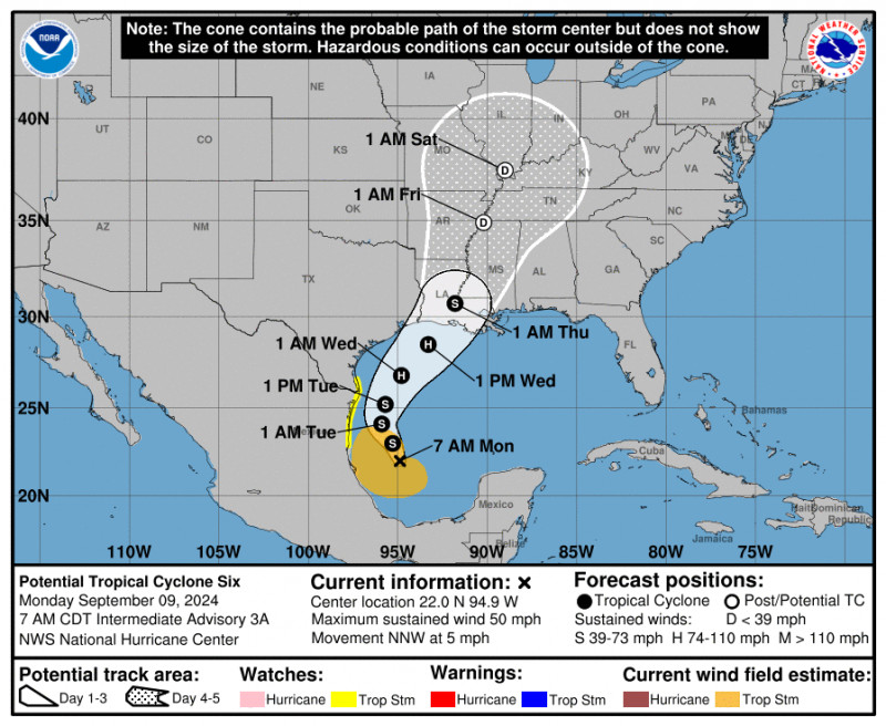
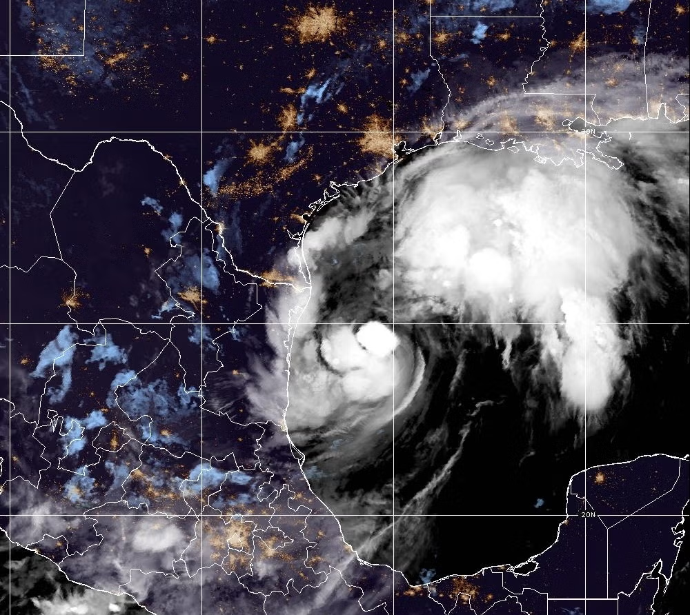
A tropical cyclone swirling in the Gulf of Mexico is expected to strengthen into a hurricane this week, bringing life-threatening storm surge, flash flooding, and hurricane force winds to the Texas and Louisiana coastlines.
The system, which is currently churning more than 545 miles south of Louisiana’s Cameron Parish, is forecast to become “Francine” on Monday. It will be the Atlantic hurricane season’s sixth named storm.
The National Hurricane Center said Monday that storm surge and tropical storm watches would likely be required for parts of the Louisiana and Upper Texas coasts. Tropical storm conditions were possible for the southernmost reaches of Texas on Tuesday.
As the storm shifts toward the U.S. on Wednesday, the agency said it has the potential to bring rainfall totals of four to eight inches, with local amounts of as many as 12 inches from the coast of far northeast Mexico through the southern portions of Texas, Louisiana, and Mississippi. The rainfall will threaten these areas with considerable flash and urban flooding into Friday morning.
The National Weather Service wrote on social media that it was too soon to determine the exact location and magnitude of impacts from the storm, but warned that the potential for life-threatening storm surge and damaging winds are increasing.
The hurricane is slated to provide some relief from extreme heat that’s swept over much of the southern U.S. in the last week, causing stress on crops. That heat will continue to bake other U.S. regions on Monday and Tuesday.
These predictions come following an eerily quiet period in the Atlantic this summer. The fifth named storm was Ernesto, which strengthened into a hurricane in mid-August. Although September is known as peak hurricane season, not a single named storm had formed since then.
The season is still projected to be above average, with a forecast from the National Hurricane Center predicting as many as 24 named storms at the beginning of last month.
And, it got off to an explosive start. Hurricane Beryl, the first major storm of the season, formed in late June. In July, it became the earliest Category 5 hurricane observed in the Atlantic and the strong July Atlantic hurricane ever recorded.
Beryl lashed Bermuda, bringing major swells to U.S. coasts. In July, preliminary figures showed the hurricane may have caused up to $32bn worth of damage. The storm killed at least seven people.
As the global climate warms, NASA scientists predict that hurricanes will cause more intense impacts. Those threats include increased rainfall totals and higher storm surge.
The Independent will be revealing its Climate100 List in September and hosting an event in New York, which can be attended online.
Disclaimer: The copyright of this article belongs to the original author. Reposting this article is solely for the purpose of information dissemination and does not constitute any investment advice. If there is any infringement, please contact us immediately. We will make corrections or deletions as necessary. Thank you.