Comparison photos shared on social media show the impact of unusually heavy rain in the Sahara Desert.
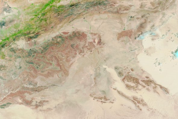
The before-and-after photos included satellite images of the Sahara Desert, known as the world's largest hot desert, taken in 2023 and 2024. In the first photo, the terrain is mostly dry. However, the second photo reveals an explosion of greenery as plant life thrives from the wet weather pattern, which is the result of a shifting monsoon.
"The southern Sahara Desert is incredibly green this year due to a northward shift of the monsoon across Africa," extreme storm chaser Colin McCarthy posted with the photos on X, formerly Twitter, on Tuesday.
McCarthy credited the plant life to a shift in the monsoon, a change that has killed more than 1,000 people across Africa because of severe flooding and displaced millions of others.
"This northward shift of the Intertropical Convergence Zone (ITCZ) has brought heavy rains and extreme flooding to the region. Over 1,000 people have been killed by flooding in Central and Western Africa, with millions displaced," McCarthy said in a follow-up post.
National Weather Service (NWS) Weather Prediction Center lead forecaster Bob Oravec told Newsweek that data shows heavier rainfall has been documented across parts of the Sahara.
On average, the Sahara receives between zero and 3 inches of rain per year. However, according to average rainfall maps from the NWS Climate Prediction Center, some parts of the desert in northern Africa saw as much as 600 percent of the average precipitation over the past 30 days.
The change in weather patterns also has disrupted the 2024 Atlantic hurricane season. Earlier this year, experts predicted a particularly active season, pointing to warm ocean surface temperatures and the El Niño climate pattern.
"However, this northward shift of the monsoon trough has actually led to a decrease in Atlantic hurricane activity," McCarthy posted. "Most hurricanes in the Atlantic originate off the west coast of Africa as tropical waves, but due to the northward shift of the monsoon, these waves have been exiting Africa into cooler waters, inhibiting tropical cyclone development."
As of mid-September, there have been only seven named storms that have impacted the U.S. from the Atlantic Ocean. The most recent was Tropical Storm Gordon, which has weakened into remnants out at sea without making landfall anywhere.
The National Hurricane Center is not tracking any other disturbances in the Atlantic as of Wednesday. However, several meteorologists have expressed concerns of a possible system that might develop in the southern Gulf of Mexico or western Caribbean next week, although no forecasts have been issued.
Disclaimer: The copyright of this article belongs to the original author. Reposting this article is solely for the purpose of information dissemination and does not constitute any investment advice. If there is any infringement, please contact us immediately. We will make corrections or deletions as necessary. Thank you.